
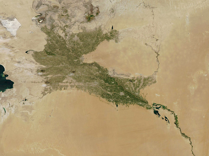
On September 9th, NASA published a satellite image of the Amu Darya River on its website. The image description states that on September 4th, 2023, the Moderate Resolution Imaging Spectroradiometer (MODIS) on NASA's Aqua satellite captured a full-color image of the green belt surrounding the Amu Darya River in Uzbekistan and Turkmenistan, Orient.tm reports.
"The Amu Darya River flows from the high Pamir Mountains in Central Asia through the scorching desert and eventually into the Aral Sea. As one of the largest rivers in the region, it is literally a lifeline: it makes deserts green and allows people, plants, and animals to thrive."
The description also touches upon the Aral Sea. "In the upper left corner of this image (northwest), you can see a white salt flat. To the east of it lies an area of cracked soil, patches of greenery, and water pools. This depleted soil marks the southern boundary of the once prosperous Aral Sea. Once a vast and mighty inland sea, the Aral Sea began to die as the water in its feeding rivers (the Amu Darya and Syr Darya) began to divert and the flow of water decreased. Today, much of the Aral Sea has dried up, leaving behind nothing but desiccated, hyper-saline soil that easily turns into airborne dust."
Attention is also drawn to the unique and ecologically important forest ecosystem known as "tugai," which exists only along major rivers in the deserts of Central Asia. "Tugai forests are rich in Euphrates poplar, various shrubs, and grasses. They provide a critically important habitat for a variety of species, especially migratory birds. Drought and heat-resistant vegetation is crucial in preventing desertification, protecting against sandstorms, and preserving biodiversity."
CentralasianLIGHT.org
September 10, 2023